Chandigarh - Infrastructure
Infrastructure
Mr. Le Corbusier conceived the master plan of Chandigarh as analogous to human body, with a clearly defined head (the Capitol Complex, Sector 1), heart (the City Centre Sector-17), lungs ( the leisure valley, innumerable open spaces and sector greens), the intellect (the cultural and educational institutions), the circulatory system (the network of roads, the 7Vs) and the viscera (the Industrial Area). The concept of the city is based on four major functions: living, working, care of the body and spirit and circulation. Residential sectors constitute the living part whereas the Capitol Complex, City Centre, Educational Zone (Post Graduate Institute, Punjab Engineering College, Panjab University) and the Industrial Area constitute the working part. The Leisure Valley, Gardens, Sector Greens and Open Courtyards etc. are for the care of body and spirit. The circulation system comprises of 7 different types of roads known as 7Vs. Later on, a pathway for cyclists called V8 were added to this circulation system.
The Capital complex comprises three architectural masterpieces: the "Secretariat", the "High Court" and the "Legislative Assembly", separated by large piazzas. In the heart of the Capital Complex stands the giant metallic sculpture of The Open Hand, the official emblem of Chandigarh, signifying the city's credo of "open to given, open to receive".
Roads
One unique feature in the layout of Chandigarh is its roads, classified in accordance with their functions. An integrated system of seven roads was designed to ensure efficient traffic circulation. Corbusier referred to these as the 7'Vs. the city's vertical roads run northeast/southwest (the 'Paths'). The horizontal roads run northwest/southwest ('The Margs'). The intersect at right angles, forming a grid or network for movement.
This arrangement of road-use leads to a remarkable hierarchy of movement, which also ensures that the residential areas segregated from the noise and pollution of traffic.
Each 'Sector' or the neighboured unit, is quite similar to the traditional Indian 'mohalla', Typically, each sectors measures 800 metres by 1200 metres, covering 250 acres of area. Each Sector is surrounded by V-2 or V-3 roads, with no buildings opening on to them. Access from the surrounding roads is available only at 4 controlled points, which roughly mark the middle of each side. Typically a sector is divided in four parts by a V-4 road running from east to west and a V-5 road running from north to south. These four parts are easily identifiable as A, B, C and D corresponding to North, East, South and West sides. Each Sector is meant to be self-sufficient, with shopping and community facilities within reasonable walking Though educational, cultural and medical facilities are spread all over city,.
The industrial area comprises 2.35 sq kms, set-aside in the Master Plan for non-polluting, light industry on the extreme southeastern side of the city near the railway line, as far away from the Educational Sectors and Capitol Complex as possible.
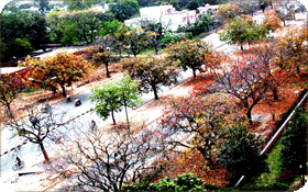
Tree plantation and landscaping has been an integral part of the cityżs Master Plan. Twenty six different types of flowering and 22 species of evergreen trees (Sing et. Al., 1998) have been planted along the roads, in parking areas, shopping complexes, residential areas and in the city parks, to ameliorate the harsh climate of the region, especially the hot and scorching summers.